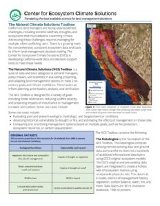
California needs relevant, actionable information to tackle the tremendous challenge of managing its natural lands in the face of climate change. While a vast amount of geospatial data exists, there are few scientifically rigorous, stakeholder-informed methods that have produced tailored, integrated data for decision makers.
The Center for Ecosystem Climate Solutions (CECS) is supporting the state’s land management needs through data-driven science and technology. CECS is powered by a team of nearly 50 scientists at 8 research institutions, with support from partners at state and federal agencies, nonprofits, and the private sector, all working together with the goal of developing thoroughly evaluated, accessible data products to inform and optimize land management decisions.
Core Commitments & Desired Project Outcomes:
Build on and leverage decades of research to understand and prepare for the impact of climate change on California’s wildlands
Asses the outcome of past management efforts on land surface characteristics
Provide geospatial tools to help predict the effects of disturbances and management actions
Directly engage stakeholders at every step in the research and tool development process
Yield a significant net reduction in emissions using strategies that are easily replicable and scalable
Quantify and maximize land management co-benefits, which will disproportionately accrue to low-income, rural areas. Potential benefits include:
Reducing wildfire risk and severity
Maintaining water quality and quantity
Maintaining natural carbon sequestration and storage