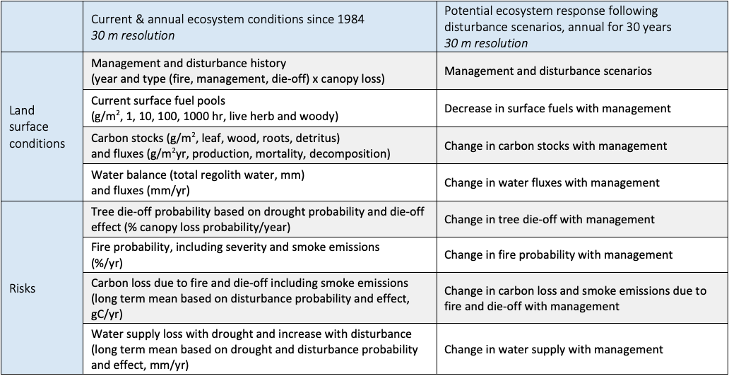
CECS has developed remote sensing and geospatial tools to consistently quantify current conditions and the effects of past and ongoing management on an integrated, statewide scale. This data covers numerous categories of land surface characteristics, including:
- Biomass stocks and carbon dynamics
- Water balance and the delivery of runoff to rivers and groundwater
- Vegetation cover, and management or disturbance history
- Surface fuels and wildfire spread and severity.
To achieve this, CECS researchers collected and homogenized existing data on these ecosystem metrics, and then improved upon this existing data by creating new datasets to fill critical gaps. This includes data on surface fuels, detrital carbon stocks, vegetation disturbance, and water and carbon exchanges. This data spans from 1986 to present, allowing users to examine the effects of past management or disturbance.
 Datasets homogenized/produced by CECS.
Understanding trends in past disturbances like wildfire, timber harvests, and tree die-off and their long-term effects on ecosystem services is central to quantifying the net benefits of different management options.
Using refined, integrated geospatial datasets, the CECS team is examining past wildfires and other disturbances to better understand how ecosystem services change over several decades post-disturbance. CECS is generating recovery curves for areas impacted by such disturbances, showing the immediate post-disturbance effect, half-life, and integrated effect. Using machine learning, these recovery curves from past disturbances can be used to project the effects of proposed future management actions.
This information will ultimately be available as part of the CECS Natural Climate Solutions Toolbox for stakeholders and decision makers to weigh management choices according to priority ecosystem service benefits.
 Credit: Brie Anne Coleman, Placer County Water Agency.
Informed by input from our stakeholders, CECS has developed the Natural Climate Solutions Toolbox, a suite of open-source tools for scientists, land managers, policy makers, and the public. The NCS Toolbox contains the following capabilities:
- Select and Download Data: With the DataBridge users can tailor, download, and utilize spatial datasets from hundreds of integrated layers of ecosystem data.
- Data Visualization: With the DataAtlas, users explore an interactive map to assess geospatial trends of key attributes and identify areas for further analysis.
- Decision Support: With the DataBridge users can also compare potential management decisions based on their chosen priorities, and monitor the impacts of past management or disturbance through time.
Upcoming capability: Ecosystem service valuation. This component of the NCS Toolbox is currently in development and will allow users to apply monetary values to the ecosystem benefits and costs of land management outcomes.
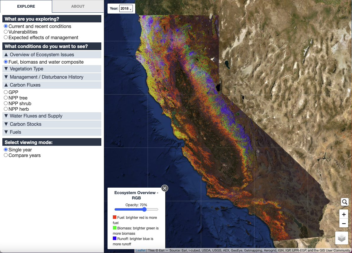
The DataAtlas allows users to quickly visualize select data from the NCS Toolbox, including conditions through time, ecosystem vulnerabilities, and the potential effects of management.
Forest restoration provides many benefits in addition to reducing the risk of high-severity wildfires, including sustaining forest carbon stores, increasing streamflow and water supply, reducing the threat of erosion, and much more, with beneficiaries at many scales. The ability to project and verify these many benefits is key to driving public and private investments in restoration projects, but there are few methods available to do so.
The CECS team is developing tools for valuing ecosystem services in order to overcome key information roadblocks to monetizing the benefits of restoration and apportioning benefits. The primary focus is on carbon, water, and wildfire risk reduction, further extending to air quality, public health, and local community benefits.
These valuation tools can be leveraged to support partnerships and agreements, on a project-by-project basis, to motivate project investments from the different beneficiaries, accelerating the pace and scale of much needed restoration.
 Credit: Brie Anne Coleman, Placer County Water Agency.